Drew An-Pham
Collection of my GIScience Work
Error and Uncertainty in GIS
A common misconception the general public often has about cartographic layouts, visualizations of space, and geographic research are that they represent reality. However, as asserted by Longley et. al, “it is impossible to make a perfect representation of the world, so uncertainty about it is inevitable” (128). As geographers, we must acknowledge our representations of space will always re-present (distort) reality, rather than embrace it. However, this subjectivity makes these representations more accurate for some, yet more distant for others—everyone is entitled to their own ‘version of reality’. Hence, Chapter 6 of Longley et al. (2008) dives into and discusses the principal sources of uncertainty as you move from the ‘real world’ to ‘analysis,’ as seen in figure 6.1.
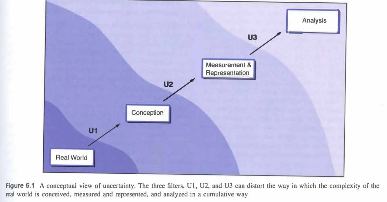
Each intermediary step (labeled as U1, U2, U3) represents a filter where the distortion of data or error can occur, which can impact the way the real world is conceived, measured, represented, and analyzed. Reflecting on my first-hand experiences with uncertainty, in GEOG 0126, we worked with raster layers denoting land cover, during our sustainable development unit. As noted in the chapter, “errors in land cover maps can occur in locations of boundaries of areas, as well as in classification of areas” (139). While I had never thought to check these land cover classifications provided to us, this would’ve helped omit any mislocated boundaries and misallocated classes I may have produced in my final cartographic layout. Likewise, the use of self-chosen boundaries and symbology presented a degree of vagueness in my maps, where I had to consider both the cartographic and cognitive implications this had on the work I was producing.
I believe as geographers, one of key responsibilities we should be held accountable for with regards to uncertainty in research is transparency and acknowledging these errors are to be expected in GIS. Whether that’s bringing attention to these uncertainties in documentation or explicitly stating ones intentions behind depicting some spatial feature in a re-presentive light, geographers are capable of fulfilling these responsibilities in an ethical and well-intentioned manner. An application of these responsibilities within the framework of Longley et al. (2008) can be seen in a case study of tree mapping. At U1, the lack of objective geographic individual units could result in the subjective classification of tree zones by relative incidences of tree type, where significant tree-points are aggregated into area objects. While the intent is create a well-defined boundary, this vagueness propagates uncertainty about the positions of these tree zones’ boundaries and their associated attributes (tree points). At U2, positional errors can be made if tree features aren’t positioned to an accuracy of ~0.5 mm. At U3, uncertainty in how our tree data was collected can iterate into further uncertainties in the results of our GIS analyses. However, part of the benefit of GIS is that it enables users flexibility when working with aggregate data and helps us validate these data with reference to externally available sources. Hence, if a geographer were to address, discuss, and at best, resolve these uncertainties/sources of error in a section of the research (this shouldn’t be the primary focus, however), they’d successfully create an ethic of transparency and accountability that fellow spatial researchers could adopt and apply when referencing their work.
Sources
- Longley, P. A., M. F. Goodchild, D. J. Maguire, and D. W. Rhind. 2008. Geographical information systems and science 2nd ed. Chichester: Wiley. (only chapter 6: Uncertainty, pages 127-153)